Model Cycle: 2010 DEC 31 12Z
  Time Zone: GMT - 5 hours
-------------------------------------------------------------
             SURF    SURF DIR   SEAS  PERIOD   WIND    WND/DIR
             (ft)       (deg)   (ft)   (sec)   (kts)     (deg)
            -------  --------  -----  ------  -------  -------
12/31  7am   6 - 13    N 357    9.0    12.1   18 - 24   NE  46
12/31  1pm   5 - 11    N 358    8.4    11.6   17 - 23   NE  43
12/31  7pm   5 - 10    N 358    8.0    11.2   16 - 22  ENE  57

1/1    7am   4 -  8    N   0    7.2    10.3   15 - 21  ENE  59
1/1    1pm   2 -  5  NNE  29    6.7     6.3   16 - 21  ENE  54
1/1    7pm   2 -  5   NE  39    7.2     6.5   17 - 23  ENE  62

1/2    7am   3 -  6   NE  34    7.1     7.1   17 - 23  ENE  60
1/2    1pm   3 -  6  NNE  28    6.8     7.5   14 - 19  ENE  58
1/2    7pm   3 -  6  NNE  29    6.7     7.6   16 - 21  ENE  58

1/3    7am   3 -  6   NE  37    7.0     7.6   14 - 19  ENE  68
1/3    1pm   3 -  6   NE  38    6.9     7.6   16 - 22  ENE  54
1/3    7pm   2 -  5   NE  38    6.6     7.4   16 - 21  ENE  58

1/4    1am   2 -  5   NE  39    6.0     7.2   16 - 21  ENE  60
1/4    7am   2 -  4   NE  38    5.5     6.8   14 - 19  ENE  64
1/4    1pm   2 -  4   NE  39    5.0     6.7   14 - 19  ENE  52
1/4    7pm   1 -  3   NE  40    5.0     6.3   14 - 19  ENE  67

1/5    7am   1 -  3   NE  45    5.0     6.6   12 - 17  ENE  73
1/5    1pm   1 -  3   NE  46    4.6     6.4   10 - 13  ENE  51
1/5    7pm   3 -  7  NNE  24    4.4    13.3   10 - 13  ENE  66

1/6    7am   2 -  5  NNE  19    4.0    11.5    8 - 11  ENE  78
1/6    1pm   2 -  5  NNE  15    4.1    10.8    7 -  9  NNE  25
1/6    7pm   2 -  5  NNE  12    4.4    10.3    9 - 13   NE  44

1/7    7am   1 -  3    N   6    3.3     9.1    2 -  3    E  85
Friday, December 31, 2010
PRNW Forecst of 12/31/2010
Friday, September 10, 2010

Igor Cometh!
Igor regained strength and is now a tropical storm and expected to gain hurricane strength by Monday. He will develop rapidly. Long period swell begins arriving to Cape Hatteras during Wednesday night (the 15 - 16 sec variety) with small swells initially - pray for light offshores. Thursday and Friday will be surf days... looks like I will be leaving late Friday. This storm really gets big. Looks like Sun/Mon surf sessions in the DelMarVa upon my return.

You can practically fit Puerto Rico into the eye of the storm.
Thursday morning swell starts out small...

...but is powered by long period 15-16 sec. swell


You can practically fit Puerto Rico into the eye of the storm.

Thursday morning swell starts out small...

...but is powered by long period 15-16 sec. swell

Wax those boards, boys!!!!
Thursday, September 9, 2010
Update for gP3 Week
Had to check this evening... Igor is more favorable in providing swell
for us. Now expect forerunner long period swell (small, 13-16 sec
periods) to start arriving on Wed with increasing swell size on
Thursday. My guess is we will now have swell on Thu & Fri, maybe
something on Wed, and certainly on Sat for those still hanging around.


Wednesday, September 8, 2010
Later in gP3 Week
We will need to scope out the incoming tide sandbars for 2-3 foot surf
early- and mid-week. Late in the week we might see some nice SE'ly
swells from Igor.
This figure clearly shows the track location of the storm.

This figure shows the intensity of the storm.

This figure shows the groundswell approach on Wednesday (that makes it one day away from Hatteras).

This figure shows Igor (western storm) and Julia (?) to the east.

____________________________________________________
Rod Rodgers _\m/
http://rodndtube.com/
http://mypaipoboards.org/
Monday, September 6, 2010
The One Named Hermine
Well, the one I have been calling Hermine still remains nameless and in
the meantime, Hermine formed in the Western Gulf of Mexico. That would
make "my" Hermine an Igor. Meanwhile, the tropical low pressure system
that once was called Gaston is still given a 70 percent chance to
reform. Another model shows a good-sized storm in the middle of the
Atlantic on Sept 13th with another storm coming off Africa (this one
would be too late for Hatteras Week).
--
____________________________________________________
Rod Rodgers _\m/
http://rodndtube.com/
http://mypaipoboards.org/
Sunday, September 5, 2010
All is quiet for now
Storms are still gathering even though it appears quiet. The storm named
Gaston may reform but looks headed through the Caribbean and into the
Gulf of Mexico. Will it eventually curve north from the Gulf and head
north? This has happened before and brought us several days of waves
from the south.
The Invest that I have called the potential Hermine has disappeared from
some models but shows up in others. Another tropical wave is coming off
of Africa and forecast to develop into a TS... in time for gP3?
Swell Info is forecasting waist high surf from Rodanthe to Frisco on
Saturday.

This is today's situation.

This is the forecast for Sept. 12th.

This is the forecast for Sept. 12th.

Saturday, September 4, 2010
Gaston has Disappeared, Hermine has Not

Hatteras Week picture... 2nd half of the week.
Friday, September 3, 2010
P3 Wave Makers?

For the two figures below, the estimated arrival time for swell from Gaston (near Puerto Rico) is 2 to 3 days.


____________________________________________________
Rod Rodgers _\m/
http://rodndtube.com/
http://mypaipoboards.org/
Thursday, September 2, 2010
TS Setup for P3 Week
The current Conga Line of Earl, Fiona and Gaston, the latter of which might provide some swell at the beginning of P3 Week.

Looking out 180 hours you will see Gaston over Puerto Rico and what hopefully would become Hermine off the Cape Verde Islands (she could provide swell later during P3 Week).

This satellite picture shows the Conga Line and what could be Hermine coming off the Africa coast.


Looking out 180 hours you will see Gaston over Puerto Rico and what hopefully would become Hermine off the Cape Verde Islands (she could provide swell later during P3 Week).

This satellite picture shows the Conga Line and what could be Hermine coming off the Africa coast.

Wednesday, September 1, 2010
NAH Wed Forecast for Hurricane Earl at OBX
Top figure shows Thursday Night and bottom figures shows Friday morning, as of morning of Wed, Sept 1st,.


Tuesday, August 31, 2010
P3 Storm of Hope: Invest98


--
____________________________________________________
Rod Rodgers _\m/
http://rodndtube.com/
http://mypaipoboards.org/
Eye of Earl Near San Juan

--
____________________________________________________
Rod Rodgers _\m/
http://rodndtube.com/
http://mypaipoboards.org/
Saturday, August 28, 2010
Earl to Put a Hurting on OBX
Check this out... Hurricane Earl will be hanging off the NC OBX coast
for about 40 hours, or more. My guess is a Cat 3 or Cat 4 strength storm.
At 138 hours from 8/28/10:

At 180 hours from 8/28/10:

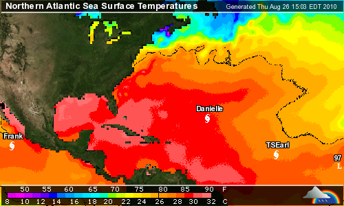
Thursday, August 26, 2010
Monday Looking Green

East Coast.


A Couple Days Later Conga Line Forecast
Invest97, shown as 97L in this figure, should become Fiona sometime in the next few days.

Tuesday, August 24, 2010


Monday, August 23, 2010
2010-0823 Forecast for Mon Aug 30 timeframe

Good news: Invest 96 just joined the conga line. Bad news - long range forecast at this point shows a slightly weaker storm than Danielle that also follows here track into the Mid-Atlantic.


Sunday, August 22, 2010


Saturday, August 21, 2010


Subscribe to:
Comments (Atom)