Monday, March 14, 2022

CRNW Forecast and Report of Mon, 2022-0314 11am

Looks like rideable surf throughout the period although the 2-3 ft days can be touch-and-go depending upon a number of factors. None of the primary swells appear to be in the blockage lines although some of the less influential secondary swells might be. Winds appear to remain offshore until afternoon through Wed, then late-morning to noon after that, in the first week of the forecast. The Outer Wash appears to be a low-probability event although it might be worth a venture if we see it breaking since these swells are not very long period or large.

Both boards are packed and upstairs ready for loading for the airport ride... which one shall it be? Stay tuned to the long-range forecast later this evening.


The forecast below is from 3 days ago (updates late-afternoon or early-evening).

Long Term Forecast Analysis Monday,  March 14th and Beyond)

SPAC Overview:

Fading SSW swell on Monday shows most size in the morning, for waist to chest high+ surf at good exposures. Slow drop follows that afternoon. Next up, another fun zone SSW swell moves in by Tuesday, then peaks through the middle of the upcoming week, setting up a new round of waist to shoulder high+ surf for many exposures on Wednesday and Thursday, 16th-17th, as best breaks hit head high. Similar strength shot of SSW swell rolls in for the weekend, 19th-20th, maintaining fun surf.

Fresh Southern Hemi  on the way for next week.

Further out, SPAC staying active. Progs showing a healthy looking storm tracking out from under New Zealand, and setting up the potential of another run of good, long-period SSW swell peaking on the 25th-26th.  We’ll keep you posted on the progress of that storm/swell system as it develops.


Tuesday, March 8, 2022

CRNW Forecast and Report of Tue, 2022-0308 am

 Looks like a good run of consistent surf during our period of interest. It appears that seasonal coastal winds are slipping in, morning offshores, midday onshores and evening offshores returning. Surfs Up!


Winds/weather: 

Costa Rica: Steady NE winds for the northernmost spots, persist all day. The rest of North CR sees light+/moderate offshores for the first part of the mornings, shifting to mainly moderate SSW-SW-W winds later morning through the afternoon, then looking to ease later afternoon/evening. 

Long Term Forecast Analysis (Thursday,  March 10th and Beyond)

SPAC Overview:


SPAC looks to send up more fun zone swell through mid month.

Further out, another fun zone SSW swell is scheduled to move in by next Tuesday, then peak through the middle of the upcoming week, setting up a new round of waist to shoulder high+ surf for many exposures on the 16th-17th. Similar strength shot of SSW swell potential for the following weekend, 19th-20th. We’ll keep you posted on the progress of these storm/swell systems as they develop.


Saturday, March 5, 2022

CRNW Forecast and Report of Sat, 2022-0305 pm

Forecast is coming into shape and the shape is good. Look at the whopping forecast for Sunday, March 20, 2022, coming in 4.3 ft @20 sec. Holy Nelly! That will certainly change a little. But if it were to hold up we would be looking at 6-10 ft.


Some Granularity on 3/20/22
Whoops, SnL already changed their data downward, but still very good.


Here is some forecasting from a site David recently stumbled upon.


Winds/weather: 

Costa Rica: Steady NE winds for the northernmost spots, persist all day. The rest of North CR sees light+/moderate offshores for the first part of the mornings, shifting to mainly moderate SSW-SW-W winds later morning through the afternoon, then looking to ease later afternoon/evening. 

Long Term Forecast Analysis (Monday,  March 7th and Beyond)
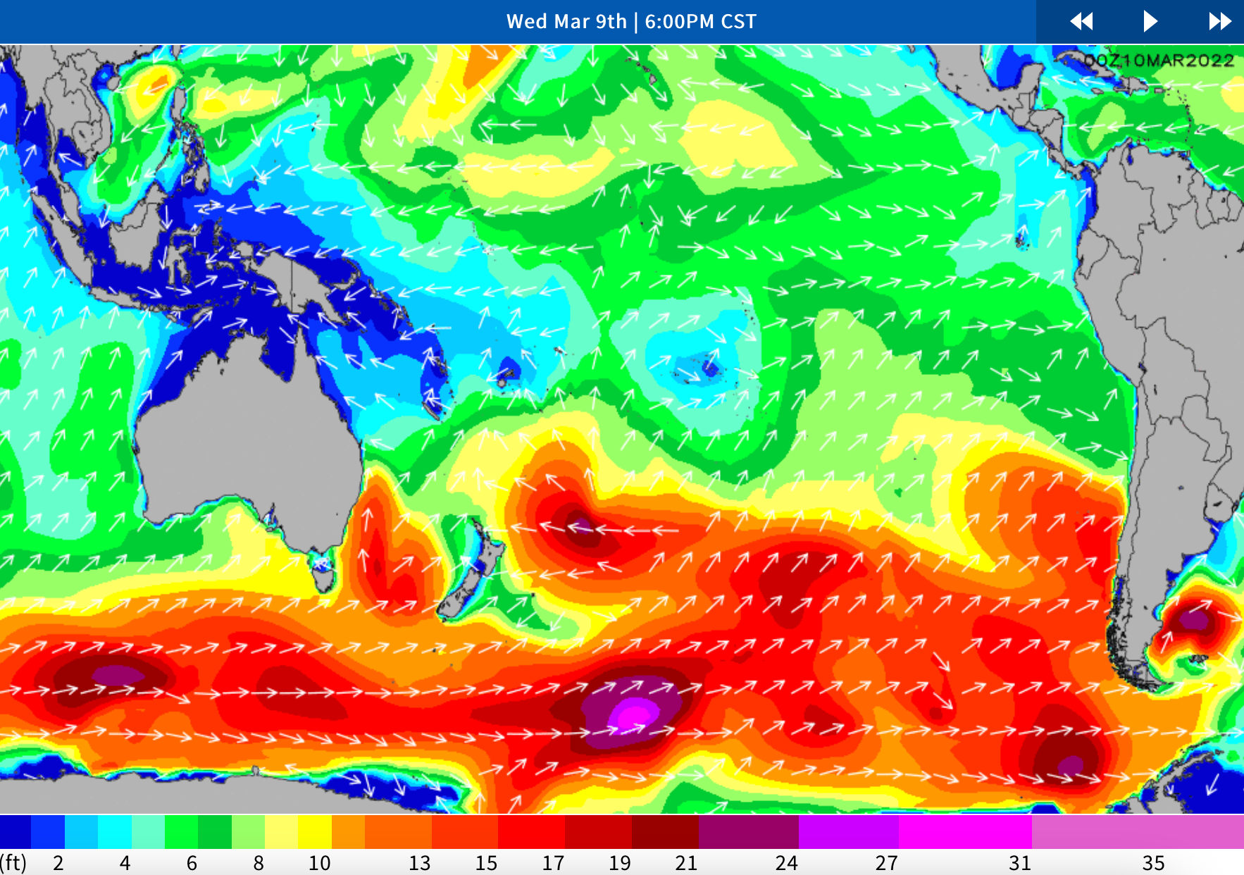
SPAC Overview:

Overall a slightly slower version of the weekend Monday and early Tuesday.  A small but playful mix of left over S-SSW swell should kick next week off as the weekend swell eases.  Exposed breaks will continue to see knee to chest high surf, with lully set waves at better exposures and magnets.

We’ve got a couple new pulses expected to help bolster the surf again.  A mix of longer-period S-SSW swell moves in Tuesday and Wednesday.  This pulse could top out with around 3 feet of deepwater swell mid to late Wednesday the 9th holding size Thursday the 10th and lingering into Friday the 11th.  Wave heights are expected to build into the waist to chest high+ range, with standouts/deepwater spots seeing sets going potentially head high-overhead during the peak.

Further out, the models are showing a small to moderate system east of New Zealand kicking up some better angled SSW that could start arriving next weekend (the 12th-13th).  It does look like the storm activity in that area has been getting the downgrade over the past couple days, so although we’re seeing more activity, it’s hard to say if it will result in any notable swells much further out.  Likely we’re going to see wave heights move back up a notch, with more waist to chest high+ surf by the end of next weekend, with potential for reinforcing energy to help maintain at least waist to chest high+ surf at SSW exposures through mid month.  Stay tuned for updates.


Friday, March 4, 2022

CRNW Forecast and Report of Fri, 2022-0304 am

The first full day is looking better and better:  4-5ft, 14mph ENE, 3.5ft 16s SSW (204º). (Cautionary Note: 204º is in our blockage window so may impede some of the flow, but some should bend in.) 


The really great news is that the share of 17-day daily forecasts in the 2-3 ft range is down especially in our trending arrival window--the one smaller 2-3 ft day is 1.4 ft @20 sec. Nonetheless, this brings up the curious question of how these numbers are derived. So, here I am looking for the day's average categorization of 20 sec swell:


Tuesday, March 1, 2022

CRNW Forecast and Report of Tue, 2022-0301 pm

We are now within the forecast window albeit the medium confidence level window. But overall, today's 17-day snapshot is more favorable than the snapshot from 17 days earlier. The forecast for our inital day is promising and the winds are back in the dominant offshore pattern again. If everything remains steady it looks like a comfy post-travel surf day with tides, swells and winds in cooperating spirits.


For your reading pleasure the tides are pasted in below but will also be found in the side links on the blog.


Winds/weather: 

Costa Rica: Steady NE winds for the northernmost spots, persist all day. The rest of North CR sees light+/moderate offshores for the first part of the mornings, shifting to mainly moderate SSW-SW-W winds later morning through the afternoon, then looking to ease later afternoon/evening. Central and southern CR will mostly see a continued diurnal wind pattern with light/variable to very light offshore flow in the early mornings trending to light+/locally more onshores in the afternoons, looking strongest in southern regions.

Long Term Forecast Analysis (Thursday,  March 3rd and Beyond)

SPAC Overview:

Modest scale SW swell shows a little more size by the half half of the week, putting more well exposed spots in waist-stomach high surf on Thursday. Friday is up a notch as a fresh SSW/S swell starts to join in. That new swell shifts more south and peaks for the weekend, for waist-chest-shoulder high waves on Saturday and into Sunday morning. Slow fade follows by the end of the weekend. Trend towards gradually easing size continues through early next week.

Further out, there is potential for a better, longer-period SSW/S swell during the 9th-11th, and again for the 13th-15th time frame. We’ll keep you posted on the progress of those storm/swell systems as they develop.