Some atypically small surf in the forecast for early- mid-week coming. Sunday will be a day to use all one's energy!

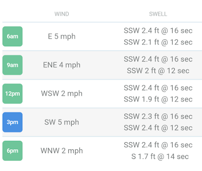
Good time to be getting out as by 9am the tide will be in a highish 8.5 ft.


Near Term Best Bets From One Day Ago
- OVER THUR/FRI: Surf will be strongest Thurs compared to Fri, but not by too much
- Early mornings and evenings to see the lightest wind and cleanest conditions
Forecast Highlights
- Best Surf in the Next 7 Days: Thurs AM, then Sat/Sun
- Old/easing SSW swell over the next few days
- Fresh pulse of fun-size SSW swell due to arrive for the weekend (partially shadowed)
Mainland Mexico and Central America Forecast From Two Days Ago
HIGHLIGHTS
- The current SSW swell eases over the next few days with a new SSW-S pulse due to arrive by the weekend
- Typical wind patterns prevail for most areas, with lightest/most favorable wind in the early mornings
- Only modest SW swell lining up for next week at this time
SHORT-TERM FORECAST (rest of this week)
A smaller, yet still sizable pulse of more southerly angled swell is en route for the weekend. Overall, we’ll see the surf decrease to a more modest yet fun-zone across the better exposures of Mainland Mex and Central America over Thurs/Fri, then bumping back up some on the weekend.
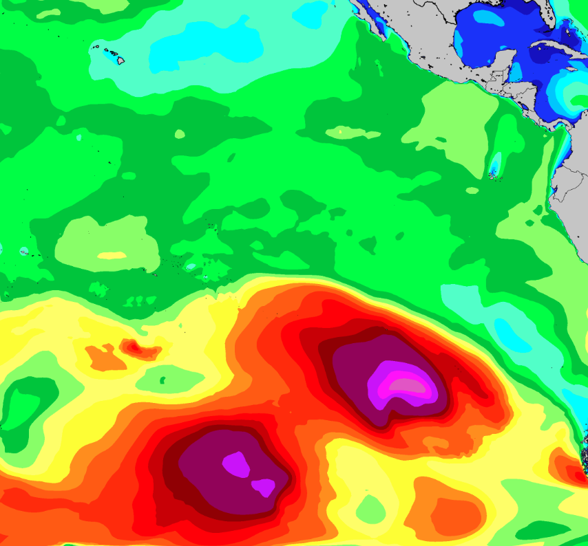
The most recent storm development near the southern tip of South America the past few days wasn’t all that large, but it was intense, packing wind speeds reaching 35-50 knots within the fetch aimed northward at Mex and Cen Am. Although the track could have been better (moved eastward instead of north), this is about as close as South Pacific storms will come to the region. The result will be a decent shot of swell (SSW 205-185° for Central America) to slowly build over Fri/Sat, topping out over Saturday and into Sunday from south to north along the coast (first for CenAm on Sat). Note that this swell will show strongest for Central America and southern most Mexico, where standout exposed breaks are looking to offer sets running in the zone of head high to 2-3 feet overhead when this energy tops out.
NOTE – There will be some Galapagos shadowing on this next swell from easternmost El Sal through Nica and northern Costa Rica, stripping a portion of the energy away and resulting in smaller, less consistent surf.
Meanwhile, we’ll continue to see the usual diurnal wind pattern across much of Central America and Mexico through the rest of this week, with widespread light/variable to light+ offshore winds in the early mornings, shifting to a light+ to moderate afternoon seabreeze. Keep an eye on the evenings for many spots to see the wind slack off before dark. Even SW Nicaragua is looking at a diurnal wind pattern for the rest of this week, but may return to the traditional ‘all-day offshores’ next week. Also, note local storms can affect the wind/conditions for select areas through each day. For a detailed look at your spots of interest be sure to check out our wind charts.
MEDIUM-TO-LONG-TERM OUTLOOK (next week and beyond)
South Pacific
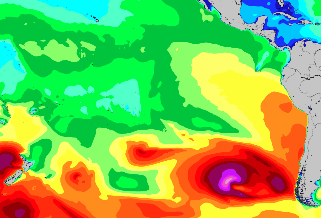
After that, the surf is looking to ease very slowly through the first-half of next week, while similar local wind conditions may persist (although, SW Nica may return back to offshores). Continued storm activity in the southeast corner of the Pacific over the next couple days will deliver fresh mid period energy from the SSW-S through Mon/Tues the 12th-13th, with sets around the chest-head high zone for top exposed breaks of Central America and Southern Mex (likely inconsistent), smaller further north.
After that, the surf is looking to ease very slowly through the first-half of next week, while similar local wind conditions may persist (although, SW Nica may return back to offshores). Continued storm activity in the southeast corner of the Pacific over the next couple days will deliver fresh mid period energy from the SSW-S through Mon/Tues the 12th-13th, with sets around the chest-head high zone for top exposed breaks of Central America and Southern Mex (likely inconsistent), smaller further north.
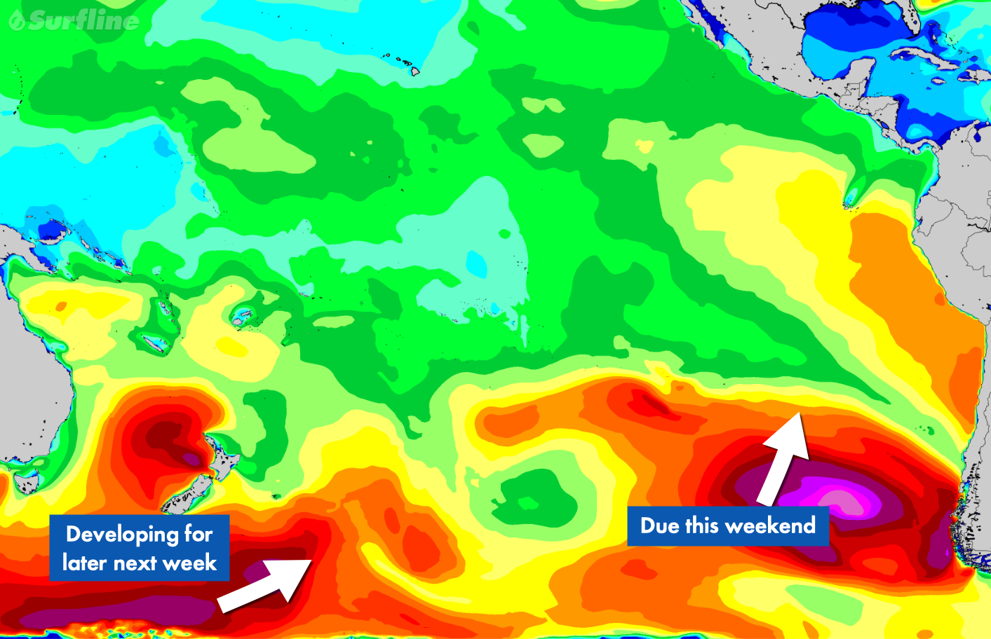
Further out, we’re currently watching the progress of a developing storm deep in the Southwest Pacific, which will evolve further as it slowly moves eastward. At this time, we’re not anticipating anything major to spawn from this system but the potential is high for at least more fun-size (head high+) surf through the second-half of next week.