We have seen larger and spunkier this time of year but not bad as La Niña continues to transition--and certainly a lot better than this past Jan-Apr. May did have quite a run of surf...


The surf appears to dip on Tue & Wed, but resumes with a healthier underlying swell on Thur.


We'll have to see how this plays out.
Mainland Mexico and Central America Forecast
HIGHLIGHTS
- SSW swell peaks Saturday then eases to end the weekend. Then a stronger pulse of SSW swell expected to peak early next week.
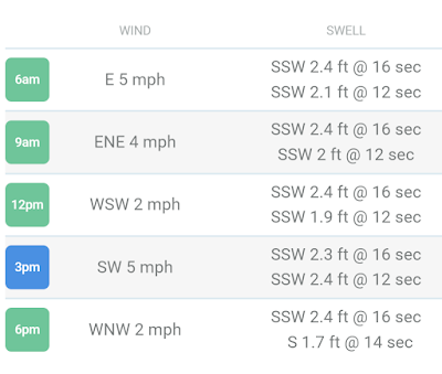
- Typical wind patterns prevail for most areas, with lightest/most favorable flow of the day in the mornings, best early
- Solid SSW swell to start the week eases into the end of the week. Fresh SPAC swell due longer range.
SHORT-TERM FORECAST (June 3rd-4th):
The SPAC keeps providing as we are looking at another round of fun-good sized surf for this weekend. Saturday AM is looking like the window to target for good size/winds as SSW swell from the end of the week tops out. We see plenty of head high to overhead surf for most areas as standouts of Central America go well overhead. Premier breaks in Mexico are hitting 2-3x overhead. There will be plenty of leftovers Sunday as old SSW swell eases. Meanwhile some new, longer period SSW swell enters the mix to end the weekend. Surf generally is around the chest to head to overhead zone Sunday, with Mexican standouts still going well overhead to double overhead+ on sets.
Just minor NW pulses due to dribble into best wintertime exposures, primarily in the Riviera Nayarit region but nothing that really gets above waist high. Summertime exposures are the easy call if you’re looking for more surf.
Standard diurnal wind pattern continues for much of Central America and Mexico through the end of the week, with widespread light/variable to light+ offshore winds in the early mornings, shifting to a modest-moderate afternoon sea breeze. Many spots see the onshores ease late afternoon into the evenings.
For a detailed look at your spots of interest be sure to check out our wind charts.
MEDIUM-TO-LONG-TERM OUTLOOK (June 5th and beyond):
South Pacific
Stronger, longer-period SSW swell is scheduled to max out early in the first full week of June, for widespread head high to well overhead waves the 5th-7th. Surf is scheduled to build on Monday, peak Tuesday, then begin to ease on Wednesday. Top breaks go 2x overhead while Mexico standouts are biggest and could go several times overhead for Tuesday. Smaller surf is expected for the rest of the week as SSW swell eases Wednesday into Friday.
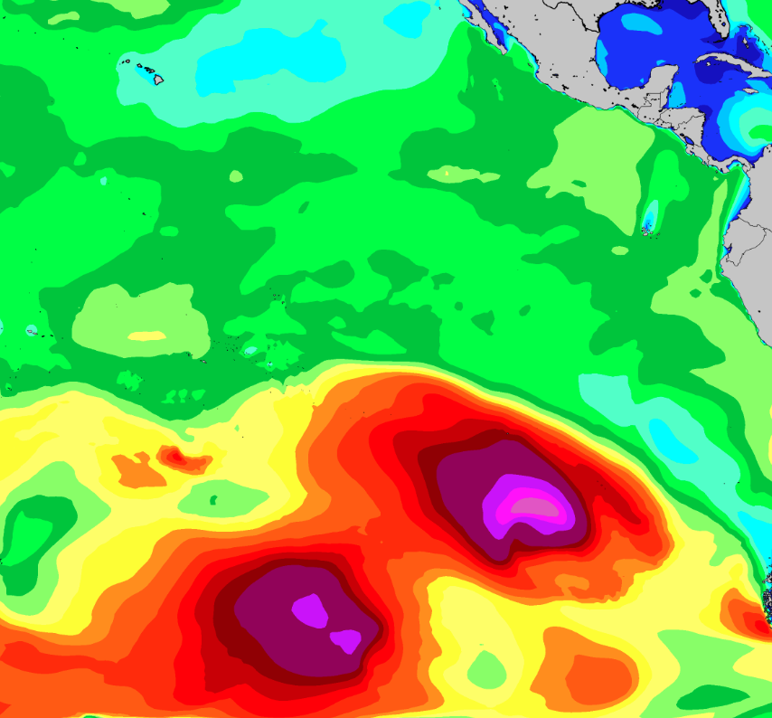
Another stronger SSW swell is due to filter in Sunday and peak early next week (5th into the 6th), courtesy of a succession of storms that tracked across the SPAC during the end of May
Then longer range we are due for another round of SPAC swell some time around the weekend of the 10th/11th, although this is not expected to be as strong as the previous swell earlier in the week. This is courtesy of storm expected to develop off the southern coast of Chile over this weekend into early week (3rd-5th) while being flanked by strong high pressure to its west. We will have a better idea of the specifics for this next swell as we gather observations this weekend into early next week. Stay tuned.
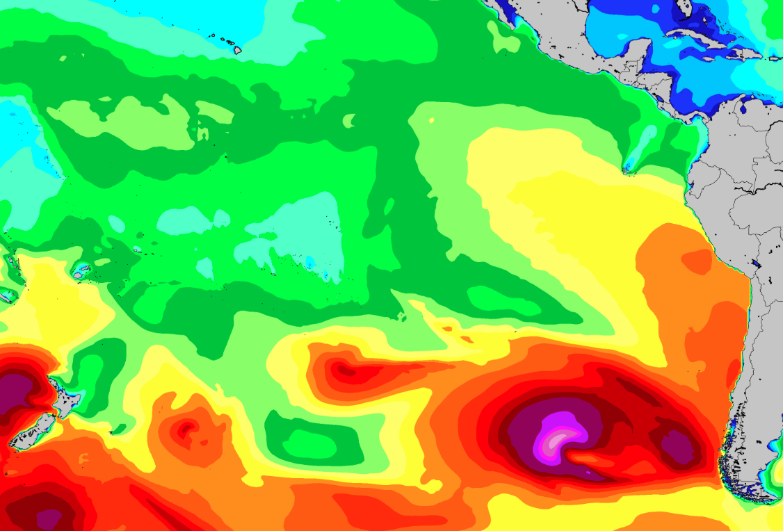
More SPAC swell due the weekend of the 10th/11th, courtesy of a developing storm in the eastern South Pacific this weekend into early week (3rd-5th). <<My emphasis added>>
No comments:
Post a Comment