Friday, June 3, 2022

CRNW Forecast of Fri, 2022-0603am

Stormy and junky looking out there this morning (630am CR time) just after a regular-sized high tide. The wind appears to be very light side shore. It won't be very motivating to paddle out some days it appears except for the notion I won't be surfing until Fall. I honestly do not think there has been a more mixed up swell in the nearly 20 years of going to CR, in Spring and early Green Season. Oh the curse of a lousy full-on La Niña.


HIGHLIGHTS 

  • Fresh SW swell moves in for the back half of the week
  • More onshore flow developing, with early mornings seeing the most favorable winds for many areas
  • Smaller Southern Hemis scheduled for the upcoming week 

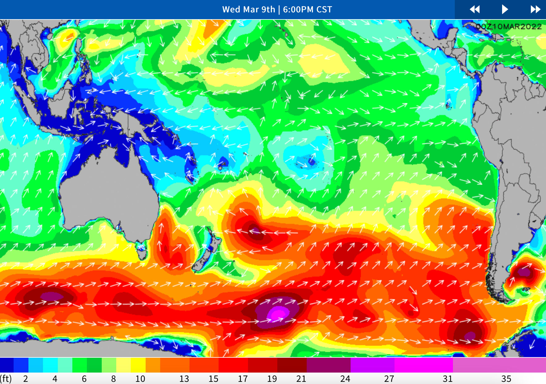
WHAT’S HAPPENING: As an old SW swell eases going into the second half of the week, a new round of  slightly stronger SW(225-215) Southern Hemi will be filling in through the day on Thursday, with good exposures getting back into shoulder to head high+ surf  during the afternoon. Those better breaks are running head high to several feet overhead when the solid SW swell maxes out on Friday. Best of the best breaks, (aka Puerto Escondido, Mex), double those heights. Waves back slide through the weekend, but there will still be plenty of head high surf left on Sunday, showing strongest in the morning.

A widespread pattern of prevailing onshore winds is expected for the next several days. Early mornings see the most favorable winds in many areas, with a rising sea breeze to follow through the day. Be sure to check the High Res Wind charts for a detailed outlook on your  spots of interest.

LONGER RANGE: The SPAC looks to take a breather for a bit, as storm/swell production drops off. That means mainly just a pair of modest scale pulses of SW and S swell scheduled for next week. The first peaks during the 7th-8th, then the second tops out for the weekend, 11th-12th. Most spots average under shoulder high during those times. Extended progs are showing potential for a bit better shot of SSW swell around the 14th-16th time frame. We’ll keep you posted on the progress of all these storm/swell systems.


Monday, May 30, 2022

CRNW Forecast of Mon, 2022-0530 noon

Still feeling as if I am just back from 4 weeks in Europe, 6 time zones away and 4 years older than my last 6-time-zones-trip (which seems to be a magnitude older that the previous similar trip just two years earlier in 2016). So... I had not looked at any forecasts while away and barely since returning. 

Yesterday I briefly looked at the Table Data source shown below and it has changed some in the past day. The one thing I noticed yesterday was the vast preponderance of swells in the 215° and greater which reflect a westerly influence in even the SW swells. I also noticed a ton of westerly swells in the secondary swells which at this time of year usually indicates a preponderance of low period onshore directed winds/wind swells.

Today I am pleased to see more S/SW swellage as primary swell sources but there still is a noticeable amount of westerly wind swell. So, what does this mean to me (not even factoring wind direction, wind strength and tides)? Surfy waves but the need for more caution and adaptation. More closeouts and a lot more sectioning waves. Some long, clean waves will still come through but the westerly wind swell will be tampering with many of those waves we choose to catch. It also means increased awareness of the inside rocks because the normal predictability of the wave can't be relied upon.

Why is all this happening? My only guess can be the La Niña forces all about us. It is also affecting the winds in these forecasts with less calm morning winds and those mostly of the side-shore/on-shore type which is atypical even during the Green Season. As Windy is showing, the Pacific's Cat3 hurricane, Agatha, is going to cross over Mexico and reform gradually in the Gulf of Mexico before crossing central FL and gathering more strength, by then a tropical storm or hurricane.


Expert Analysis From Two Days Ago, Next Update Likely This Evening

LONGER RANGE: The SPAC is staying busy. Good looking lows moving away  New Zealand are due to send up another run of SW Southern Hemi, the first slightly stronger than the one mentioned above, that tops out during the back half of the upcoming week, June, 2nd-4th, then a notch or two smaller SW swell in the 6th-8th time frame. Extended progs are showing potential for a larger round of S swell moving in for the 11th-13th. We’ll keep you posted on the progress of these storm/swell systems as they continue to develop.


This Visualization from the Captain of Surf:


Monday, March 14, 2022

CRNW Forecast and Report of Mon, 2022-0314 11am

Looks like rideable surf throughout the period although the 2-3 ft days can be touch-and-go depending upon a number of factors. None of the primary swells appear to be in the blockage lines although some of the less influential secondary swells might be. Winds appear to remain offshore until afternoon through Wed, then late-morning to noon after that, in the first week of the forecast. The Outer Wash appears to be a low-probability event although it might be worth a venture if we see it breaking since these swells are not very long period or large.

Both boards are packed and upstairs ready for loading for the airport ride... which one shall it be? Stay tuned to the long-range forecast later this evening.


The forecast below is from 3 days ago (updates late-afternoon or early-evening).

Long Term Forecast Analysis Monday,  March 14th and Beyond)

SPAC Overview:

Fading SSW swell on Monday shows most size in the morning, for waist to chest high+ surf at good exposures. Slow drop follows that afternoon. Next up, another fun zone SSW swell moves in by Tuesday, then peaks through the middle of the upcoming week, setting up a new round of waist to shoulder high+ surf for many exposures on Wednesday and Thursday, 16th-17th, as best breaks hit head high. Similar strength shot of SSW swell rolls in for the weekend, 19th-20th, maintaining fun surf.

Fresh Southern Hemi  on the way for next week.

Further out, SPAC staying active. Progs showing a healthy looking storm tracking out from under New Zealand, and setting up the potential of another run of good, long-period SSW swell peaking on the 25th-26th.  We’ll keep you posted on the progress of that storm/swell system as it develops.


Tuesday, March 8, 2022

CRNW Forecast and Report of Tue, 2022-0308 am

 Looks like a good run of consistent surf during our period of interest. It appears that seasonal coastal winds are slipping in, morning offshores, midday onshores and evening offshores returning. Surfs Up!


Winds/weather: 

Costa Rica: Steady NE winds for the northernmost spots, persist all day. The rest of North CR sees light+/moderate offshores for the first part of the mornings, shifting to mainly moderate SSW-SW-W winds later morning through the afternoon, then looking to ease later afternoon/evening. 

Long Term Forecast Analysis (Thursday,  March 10th and Beyond)

SPAC Overview:


SPAC looks to send up more fun zone swell through mid month.

Further out, another fun zone SSW swell is scheduled to move in by next Tuesday, then peak through the middle of the upcoming week, setting up a new round of waist to shoulder high+ surf for many exposures on the 16th-17th. Similar strength shot of SSW swell potential for the following weekend, 19th-20th. We’ll keep you posted on the progress of these storm/swell systems as they develop.


Saturday, March 5, 2022

CRNW Forecast and Report of Sat, 2022-0305 pm

Forecast is coming into shape and the shape is good. Look at the whopping forecast for Sunday, March 20, 2022, coming in 4.3 ft @20 sec. Holy Nelly! That will certainly change a little. But if it were to hold up we would be looking at 6-10 ft.


Some Granularity on 3/20/22
Whoops, SnL already changed their data downward, but still very good.


Here is some forecasting from a site David recently stumbled upon.


Winds/weather: 

Costa Rica: Steady NE winds for the northernmost spots, persist all day. The rest of North CR sees light+/moderate offshores for the first part of the mornings, shifting to mainly moderate SSW-SW-W winds later morning through the afternoon, then looking to ease later afternoon/evening. 

Long Term Forecast Analysis (Monday,  March 7th and Beyond)

SPAC Overview:

Overall a slightly slower version of the weekend Monday and early Tuesday.  A small but playful mix of left over S-SSW swell should kick next week off as the weekend swell eases.  Exposed breaks will continue to see knee to chest high surf, with lully set waves at better exposures and magnets.

We’ve got a couple new pulses expected to help bolster the surf again.  A mix of longer-period S-SSW swell moves in Tuesday and Wednesday.  This pulse could top out with around 3 feet of deepwater swell mid to late Wednesday the 9th holding size Thursday the 10th and lingering into Friday the 11th.  Wave heights are expected to build into the waist to chest high+ range, with standouts/deepwater spots seeing sets going potentially head high-overhead during the peak.

Further out, the models are showing a small to moderate system east of New Zealand kicking up some better angled SSW that could start arriving next weekend (the 12th-13th).  It does look like the storm activity in that area has been getting the downgrade over the past couple days, so although we’re seeing more activity, it’s hard to say if it will result in any notable swells much further out.  Likely we’re going to see wave heights move back up a notch, with more waist to chest high+ surf by the end of next weekend, with potential for reinforcing energy to help maintain at least waist to chest high+ surf at SSW exposures through mid month.  Stay tuned for updates.


Friday, March 4, 2022

CRNW Forecast and Report of Fri, 2022-0304 am

The first full day is looking better and better:  4-5ft, 14mph ENE, 3.5ft 16s SSW (204º). (Cautionary Note: 204º is in our blockage window so may impede some of the flow, but some should bend in.) 


The really great news is that the share of 17-day daily forecasts in the 2-3 ft range is down especially in our trending arrival window--the one smaller 2-3 ft day is 1.4 ft @20 sec. Nonetheless, this brings up the curious question of how these numbers are derived. So, here I am looking for the day's average categorization of 20 sec swell:


Tuesday, March 1, 2022

CRNW Forecast and Report of Tue, 2022-0301 pm

We are now within the forecast window albeit the medium confidence level window. But overall, today's 17-day snapshot is more favorable than the snapshot from 17 days earlier. The forecast for our inital day is promising and the winds are back in the dominant offshore pattern again. If everything remains steady it looks like a comfy post-travel surf day with tides, swells and winds in cooperating spirits.


For your reading pleasure the tides are pasted in below but will also be found in the side links on the blog.


Winds/weather: 

Costa Rica: Steady NE winds for the northernmost spots, persist all day. The rest of North CR sees light+/moderate offshores for the first part of the mornings, shifting to mainly moderate SSW-SW-W winds later morning through the afternoon, then looking to ease later afternoon/evening. Central and southern CR will mostly see a continued diurnal wind pattern with light/variable to very light offshore flow in the early mornings trending to light+/locally more onshores in the afternoons, looking strongest in southern regions.

Long Term Forecast Analysis (Thursday,  March 3rd and Beyond)

SPAC Overview:

Modest scale SW swell shows a little more size by the half half of the week, putting more well exposed spots in waist-stomach high surf on Thursday. Friday is up a notch as a fresh SSW/S swell starts to join in. That new swell shifts more south and peaks for the weekend, for waist-chest-shoulder high waves on Saturday and into Sunday morning. Slow fade follows by the end of the weekend. Trend towards gradually easing size continues through early next week.

Further out, there is potential for a better, longer-period SSW/S swell during the 9th-11th, and again for the 13th-15th time frame. We’ll keep you posted on the progress of those storm/swell systems as they develop.


Sunday, February 27, 2022

CRNW Forecast and Report of Sun, 2022-0227 pm

In solidarity to our friends in Ukraine we stand, hand in hand, and honor your colors!

In the realm of the surf forecast my Ukranian-colored paipo board may possibly be back in play. This most recent indicators forecast is much more to my liking than what we had been observing throughout Jan and Feb.

Indeed, the next couple days are very small. Dismal is a more accurate characterization. But in the cycle of swells having a few off days in not usual--that is why we take trips for 10-16 days.

The first positive indicator I see is the stronger shifting to more southerly swells. There are still a number of dominant swells in the upper-teens but increasing emphasis in the lower-teens, single digits and 80/90s (SW, SSW, S, respectively). These are our desired swell windows.

Another good indicator are the longer swell periodicities... 14, 15, 16, 17 secs. Now, what really blows my mind is that I briefly popped into to see the forecast this morning and it was a foot or so larger (4-4 ft or 4-5 ft) during March and many of the periodicities dropped off a second or two. This is an interesting phenomena in this forecast service!

Winds/weather: 

Costa Rica: Steady NE winds for the northernmost spots, persist all day. The rest of North CR sees light+/moderate offshores for the first part of the mornings, shifting to mainly moderate SSW-SW-W winds later morning through the afternoon, then looking to ease later afternoon/evening. Central and southern CR will mostly see a continued diurnal wind pattern with light/variable to very light offshore flow in the early mornings trending to light+/locally more onshores in the afternoons, looking strongest in southern regions.

Long Term Forecast Analysis (Monday,  February 28th and Beyond)

SPAC Overview:

Next week starts off small as a SSW pulse fades to waist high or under at most spots from Monday afternoon through Tuesday. By mid week, a new round of modest scale SW swell moves in with waist-stomach+ high waves at good exposures on Wednesday/Thursday, 2nd-3rd. Bit more size due off another SSW swell which beings filling in on Friday, then peaks over the weekend, 5th-6th, for waist-chest high surf.

Further out, smaller pulses of SSW swell scheduled for most of the following week, then there is potential for a stronger, longer-period SSW swell during the 11th-13th time frame. We’ll keep you posted on those Southern Hemis as they develop and head our way.


Friday, February 18, 2022

CRNW Forecast and Report of Fri, 2022-0218 am

The out days of the long-range forecast are an improvement. Is it a trend? Is it a passing blip? Time will tell. Bring plenty of books but be hopeful they won't be needed. Not much to say in the experts' written long-range forecast analysis. 


Tuesday, February 15, 2022

CRNW Forecast and Report of Tue, 2022-0215 am

 There appears to be more 3-4 ft surf in the 2-week forecast in today's outlook. I am also looking for more SW to S swell. At least it is appearing to be moving to that place.