Looks like some surf upcoming.


Some atypically small surf in the forecast for early- mid-week coming. Sunday will be a day to use all one's energy!

Good time to be getting out as by 9am the tide will be in a highish 8.5 ft.


HIGHLIGHTS
MEDIUM-TO-LONG-TERM OUTLOOK (next week and beyond)
We have seen larger and spunkier this time of year but not bad as La Niña continues to transition--and certainly a lot better than this past Jan-Apr. May did have quite a run of surf...


The surf appears to dip on Tue & Wed, but resumes with a healthier underlying swell on Thur.


We'll have to see how this plays out.
HIGHLIGHTS
SHORT-TERM FORECAST (June 3rd-4th):
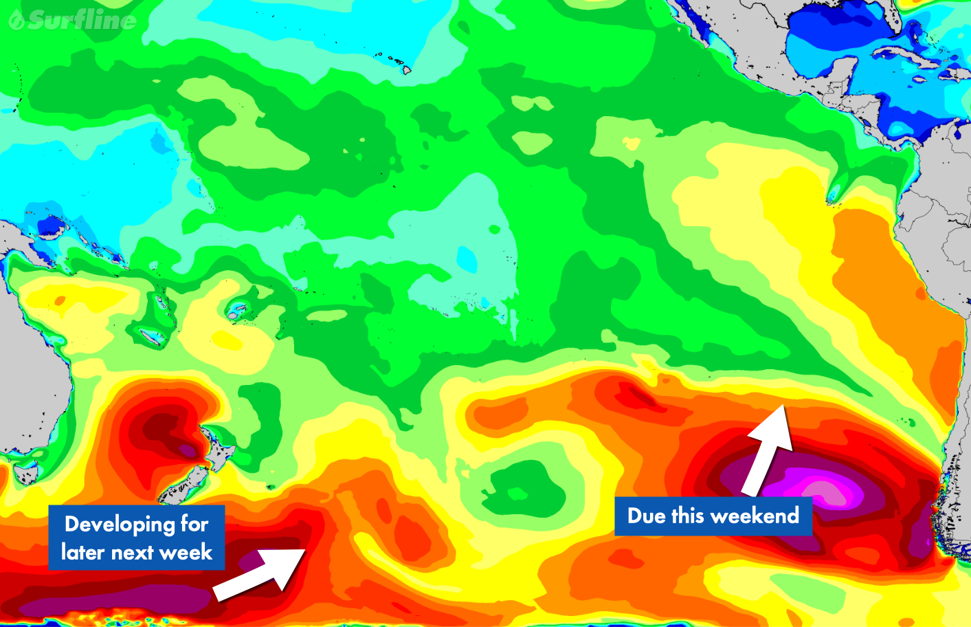
The SPAC keeps providing as we are looking at another round of fun-good sized surf for this weekend. Saturday AM is looking like the window to target for good size/winds as SSW swell from the end of the week tops out. We see plenty of head high to overhead surf for most areas as standouts of Central America go well overhead. Premier breaks in Mexico are hitting 2-3x overhead. There will be plenty of leftovers Sunday as old SSW swell eases. Meanwhile some new, longer period SSW swell enters the mix to end the weekend. Surf generally is around the chest to head to overhead zone Sunday, with Mexican standouts still going well overhead to double overhead+ on sets.
Just minor NW pulses due to dribble into best wintertime exposures, primarily in the Riviera Nayarit region but nothing that really gets above waist high. Summertime exposures are the easy call if you’re looking for more surf.
Standard diurnal wind pattern continues for much of Central America and Mexico through the end of the week, with widespread light/variable to light+ offshore winds in the early mornings, shifting to a modest-moderate afternoon sea breeze. Many spots see the onshores ease late afternoon into the evenings.
For a detailed look at your spots of interest be sure to check out our wind charts.
MEDIUM-TO-LONG-TERM OUTLOOK (June 5th and beyond):
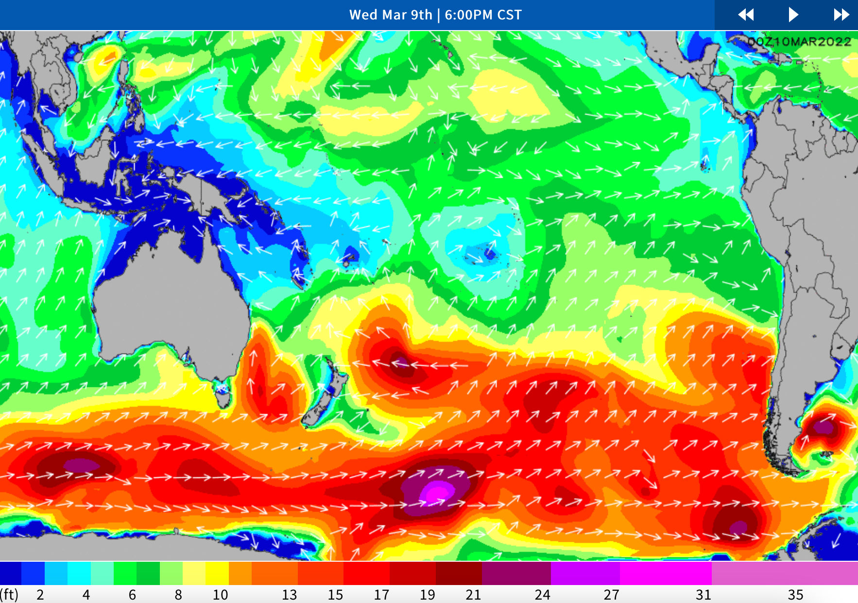
South Pacific
Stronger, longer-period SSW swell is scheduled to max out early in the first full week of June, for widespread head high to well overhead waves the 5th-7th. Surf is scheduled to build on Monday, peak Tuesday, then begin to ease on Wednesday. Top breaks go 2x overhead while Mexico standouts are biggest and could go several times overhead for Tuesday. Smaller surf is expected for the rest of the week as SSW swell eases Wednesday into Friday.
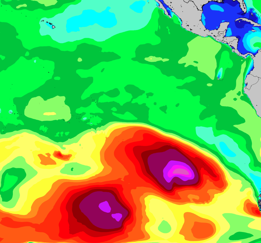
Another stronger SSW swell is due to filter in Sunday and peak early next week (5th into the 6th), courtesy of a succession of storms that tracked across the SPAC during the end of May
Then longer range we are due for another round of SPAC swell some time around the weekend of the 10th/11th, although this is not expected to be as strong as the previous swell earlier in the week. This is courtesy of storm expected to develop off the southern coast of Chile over this weekend into early week (3rd-5th) while being flanked by strong high pressure to its west. We will have a better idea of the specifics for this next swell as we gather observations this weekend into early next week. Stay tuned.
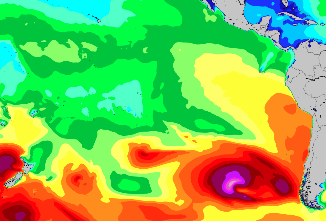
More SPAC swell due the weekend of the 10th/11th, courtesy of a developing storm in the eastern South Pacific this weekend into early week (3rd-5th). <<My emphasis added>>
The forecast has been looking good the past 4 to 6 weeks with El Niño power kicking in after three years of the sister effects. The winter and spring was slow and small -- happy about being at The Rock in March.
This weekend gets some big swell, 8-12 ft. The last day of the forecast range is also our arrival day, with 3-5 ft forecast. Although it appears to dip in the afternoon there might be something hiding in the secondary swell inside that increasing 19-20 sec period.


Below is the other famous forecasting group. The underlying surf data should be good, but I don't pay any attention to the wind forcast but offshore winds all day would be a treat, lol.


HIGHLIGHTS
WHAT’S HAPPENING: As an old SW swell eases going into the second half of the week, a new round of slightly stronger SW(225-215) Southern Hemi will be filling in through the day on Thursday, with good exposures getting back into shoulder to head high+ surf during the afternoon. Those better breaks are running head high to several feet overhead when the solid SW swell maxes out on Friday. Best of the best breaks, (aka Puerto Escondido, Mex), double those heights. Waves back slide through the weekend, but there will still be plenty of head high surf left on Sunday, showing strongest in the morning.
A widespread pattern of prevailing onshore winds is expected for the next several days. Early mornings see the most favorable winds in many areas, with a rising sea breeze to follow through the day. Be sure to check the High Res Wind charts for a detailed outlook on your spots of interest.
LONGER RANGE: The SPAC looks to take a breather for a bit, as storm/swell production drops off. That means mainly just a pair of modest scale pulses of SW and S swell scheduled for next week. The first peaks during the 7th-8th, then the second tops out for the weekend, 11th-12th. Most spots average under shoulder high during those times. Extended progs are showing potential for a bit better shot of SSW swell around the 14th-16th time frame. We’ll keep you posted on the progress of all these storm/swell systems.


Expert Analysis From Two Days Ago, Next Update Likely This Evening
LONGER RANGE: The SPAC is staying busy. Good looking lows moving away New Zealand are due to send up another run of SW Southern Hemi, the first slightly stronger than the one mentioned above, that tops out during the back half of the upcoming week, June, 2nd-4th, then a notch or two smaller SW swell in the 6th-8th time frame. Extended progs are showing potential for a larger round of S swell moving in for the 11th-13th. We’ll keep you posted on the progress of these storm/swell systems as they continue to develop.


SPAC Overview:
Fading SSW swell on Monday shows most size in the morning, for waist to chest high+ surf at good exposures. Slow drop follows that afternoon. Next up, another fun zone SSW swell moves in by Tuesday, then peaks through the middle of the upcoming week, setting up a new round of waist to shoulder high+ surf for many exposures on Wednesday and Thursday, 16th-17th, as best breaks hit head high. Similar strength shot of SSW swell rolls in for the weekend, 19th-20th, maintaining fun surf.
Fresh Southern Hemi on the way for next week.
Further out, SPAC staying active. Progs showing a healthy looking storm tracking out from under New Zealand, and setting up the potential of another run of good, long-period SSW swell peaking on the 25th-26th. We’ll keep you posted on the progress of that storm/swell system as it develops.

Winds/weather:
Costa Rica: Steady NE winds for the northernmost spots, persist all day. The rest of North CR sees light+/moderate offshores for the first part of the mornings, shifting to mainly moderate SSW-SW-W winds later morning through the afternoon, then looking to ease later afternoon/evening.
Long Term Forecast Analysis (Thursday, March 10th and Beyond)
SPAC Overview:
SPAC looks to send up more fun zone swell through mid month.
Further out, another fun zone SSW swell is scheduled to move in by next Tuesday, then peak through the middle of the upcoming week, setting up a new round of waist to shoulder high+ surf for many exposures on the 16th-17th. Similar strength shot of SSW swell potential for the following weekend, 19th-20th. We’ll keep you posted on the progress of these storm/swell systems as they develop.


Winds/weather:
Costa Rica: Steady NE winds for the northernmost spots, persist all day. The rest of North CR sees light+/moderate offshores for the first part of the mornings, shifting to mainly moderate SSW-SW-W winds later morning through the afternoon, then looking to ease later afternoon/evening.
Long Term Forecast Analysis (Monday, March 7th and Beyond)
SPAC Overview:
Overall a slightly slower version of the weekend Monday and early Tuesday. A small but playful mix of left over S-SSW swell should kick next week off as the weekend swell eases. Exposed breaks will continue to see knee to chest high surf, with lully set waves at better exposures and magnets.
We’ve got a couple new pulses expected to help bolster the surf again. A mix of longer-period S-SSW swell moves in Tuesday and Wednesday. This pulse could top out with around 3 feet of deepwater swell mid to late Wednesday the 9th holding size Thursday the 10th and lingering into Friday the 11th. Wave heights are expected to build into the waist to chest high+ range, with standouts/deepwater spots seeing sets going potentially head high-overhead during the peak.
Further out, the models are showing a small to moderate system east of New Zealand kicking up some better angled SSW that could start arriving next weekend (the 12th-13th). It does look like the storm activity in that area has been getting the downgrade over the past couple days, so although we’re seeing more activity, it’s hard to say if it will result in any notable swells much further out. Likely we’re going to see wave heights move back up a notch, with more waist to chest high+ surf by the end of next weekend, with potential for reinforcing energy to help maintain at least waist to chest high+ surf at SSW exposures through mid month. Stay tuned for updates.