Forecast is looking up for a wet first day. Small, but big enough for some stretching of the muscles and ligaments.

Central America Premium Analysis
The Bottom Line
- Swell Trend: Fun surf holds through the weekend
- Watch Out For: Mid-late afternoon high tides slow the surf down at most spots
- Other Tidbits: Stronger SPAC swell next week; watching tropics
Fun looking surf on Friday, more to come for the weekend.
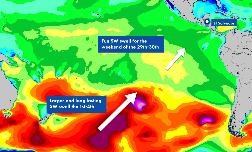
Saturday and Sunday, May 29th and 30th: Holding SSW swell for 4-6′+ surf. SSW swell peaks and holds, providing most spots with head-high+ surf and overhead sets through the weekend. Top breaks are pushing up to a couple overhead on the largest of sets.
Monday, May 31st: 4-6’+ surf from overlapping SSW swells. New SSW swell builds in all day as old SSW swell fades. Expect more consistent surf overall, with more head-high+ waves and 1-2’+ overhead sets at top breaks with the largest and strongest waves the latter part of the day as the new swell moves in.
Winds/weather: Diurnal wind pattern prevails.
Costa Rica: Light/variable to light offshore morning winds for most areas, while northernmost spots see more moderate AM offshore flow. Light+ to locally moderate onshore flow for the afternoons.
Long Term Forecast Analysis (Tuesday, June 1st and Beyond)
SPAC Overview:
Long-period SW/SSW swell peaks by mid day Tuesday and holds all day with consistent head-high+ to well overhead surf with top sets around double overhead+ at best exposures. This swell will then slowly fade going into the first weekend of June, however, the storm will be stalling in the eastern SPAC over the next several days while maintaining a weaker fetch. That will keep head-high to overhead surf going at top breaks for the 5th-8th of June.
Beyond that, we could see a fresh longer-period swell move in around the 12th and peak around mid month for another round of good size surf. We will keep you posted as that potential swell actually develops.
Tropics:
There is nothing brewing right now, but the NHC is monitoring a couple areas of disturbed weather, one SSW of Baja and the other to the south of Mainland Mexico. Both have low probability of further development, so stay tuned for any updates.
NPAC Overview:
There is no significant NW swell due for the region this week. Forecast charts do show potential for some modest scale, steep angled NW swell at best exposures around the 7th-10 of June, but that would be quite small, topping out around knee-high at best.
No comments:
Post a Comment