Looks like some surf upcoming.


Some atypically small surf in the forecast for early- mid-week coming. Sunday will be a day to use all one's energy!

Good time to be getting out as by 9am the tide will be in a highish 8.5 ft.


HIGHLIGHTS
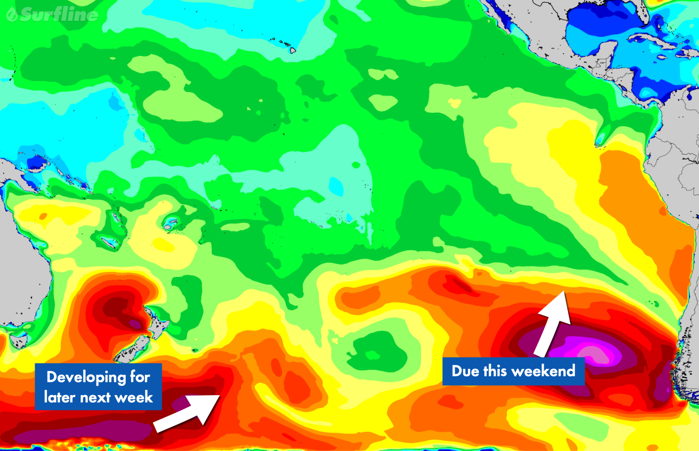
MEDIUM-TO-LONG-TERM OUTLOOK (next week and beyond)
We have seen larger and spunkier this time of year but not bad as La Niña continues to transition--and certainly a lot better than this past Jan-Apr. May did have quite a run of surf...


The surf appears to dip on Tue & Wed, but resumes with a healthier underlying swell on Thur.
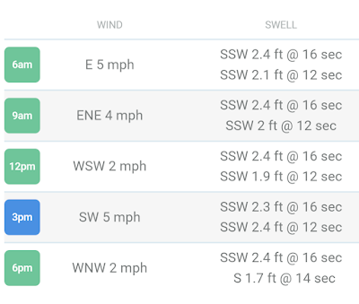


We'll have to see how this plays out.
HIGHLIGHTS
SHORT-TERM FORECAST (June 3rd-4th):
The SPAC keeps providing as we are looking at another round of fun-good sized surf for this weekend. Saturday AM is looking like the window to target for good size/winds as SSW swell from the end of the week tops out. We see plenty of head high to overhead surf for most areas as standouts of Central America go well overhead. Premier breaks in Mexico are hitting 2-3x overhead. There will be plenty of leftovers Sunday as old SSW swell eases. Meanwhile some new, longer period SSW swell enters the mix to end the weekend. Surf generally is around the chest to head to overhead zone Sunday, with Mexican standouts still going well overhead to double overhead+ on sets.
Just minor NW pulses due to dribble into best wintertime exposures, primarily in the Riviera Nayarit region but nothing that really gets above waist high. Summertime exposures are the easy call if you’re looking for more surf.
Standard diurnal wind pattern continues for much of Central America and Mexico through the end of the week, with widespread light/variable to light+ offshore winds in the early mornings, shifting to a modest-moderate afternoon sea breeze. Many spots see the onshores ease late afternoon into the evenings.
For a detailed look at your spots of interest be sure to check out our wind charts.
MEDIUM-TO-LONG-TERM OUTLOOK (June 5th and beyond):
South Pacific
Stronger, longer-period SSW swell is scheduled to max out early in the first full week of June, for widespread head high to well overhead waves the 5th-7th. Surf is scheduled to build on Monday, peak Tuesday, then begin to ease on Wednesday. Top breaks go 2x overhead while Mexico standouts are biggest and could go several times overhead for Tuesday. Smaller surf is expected for the rest of the week as SSW swell eases Wednesday into Friday.
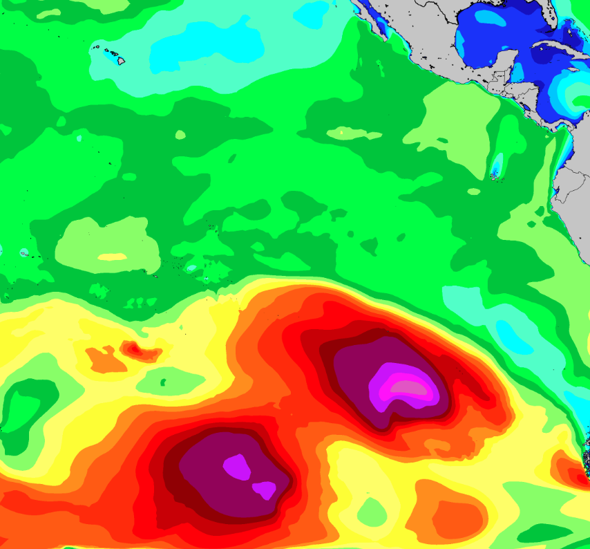
Another stronger SSW swell is due to filter in Sunday and peak early next week (5th into the 6th), courtesy of a succession of storms that tracked across the SPAC during the end of May
Then longer range we are due for another round of SPAC swell some time around the weekend of the 10th/11th, although this is not expected to be as strong as the previous swell earlier in the week. This is courtesy of storm expected to develop off the southern coast of Chile over this weekend into early week (3rd-5th) while being flanked by strong high pressure to its west. We will have a better idea of the specifics for this next swell as we gather observations this weekend into early next week. Stay tuned.
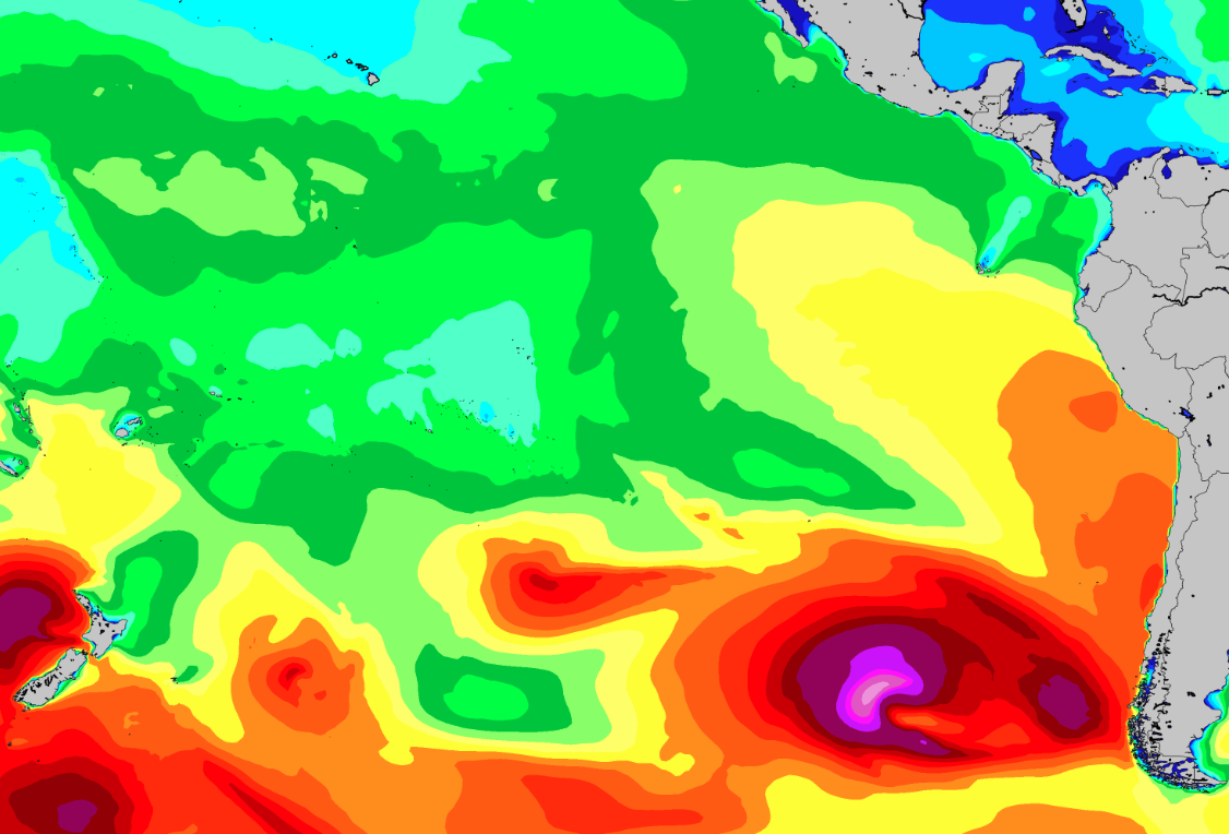
More SPAC swell due the weekend of the 10th/11th, courtesy of a developing storm in the eastern South Pacific this weekend into early week (3rd-5th). <<My emphasis added>>
The forecast has been looking good the past 4 to 6 weeks with El Niño power kicking in after three years of the sister effects. The winter and spring was slow and small -- happy about being at The Rock in March.
This weekend gets some big swell, 8-12 ft. The last day of the forecast range is also our arrival day, with 3-5 ft forecast. Although it appears to dip in the afternoon there might be something hiding in the secondary swell inside that increasing 19-20 sec period.


Below is the other famous forecasting group. The underlying surf data should be good, but I don't pay any attention to the wind forcast but offshore winds all day would be a treat, lol.


HIGHLIGHTS
WHAT’S HAPPENING: As an old SW swell eases going into the second half of the week, a new round of slightly stronger SW(225-215) Southern Hemi will be filling in through the day on Thursday, with good exposures getting back into shoulder to head high+ surf during the afternoon. Those better breaks are running head high to several feet overhead when the solid SW swell maxes out on Friday. Best of the best breaks, (aka Puerto Escondido, Mex), double those heights. Waves back slide through the weekend, but there will still be plenty of head high surf left on Sunday, showing strongest in the morning.
A widespread pattern of prevailing onshore winds is expected for the next several days. Early mornings see the most favorable winds in many areas, with a rising sea breeze to follow through the day. Be sure to check the High Res Wind charts for a detailed outlook on your spots of interest.
LONGER RANGE: The SPAC looks to take a breather for a bit, as storm/swell production drops off. That means mainly just a pair of modest scale pulses of SW and S swell scheduled for next week. The first peaks during the 7th-8th, then the second tops out for the weekend, 11th-12th. Most spots average under shoulder high during those times. Extended progs are showing potential for a bit better shot of SSW swell around the 14th-16th time frame. We’ll keep you posted on the progress of all these storm/swell systems.


Expert Analysis From Two Days Ago, Next Update Likely This Evening
LONGER RANGE: The SPAC is staying busy. Good looking lows moving away New Zealand are due to send up another run of SW Southern Hemi, the first slightly stronger than the one mentioned above, that tops out during the back half of the upcoming week, June, 2nd-4th, then a notch or two smaller SW swell in the 6th-8th time frame. Extended progs are showing potential for a larger round of S swell moving in for the 11th-13th. We’ll keep you posted on the progress of these storm/swell systems as they continue to develop.


SPAC Overview:
Fading SSW swell on Monday shows most size in the morning, for waist to chest high+ surf at good exposures. Slow drop follows that afternoon. Next up, another fun zone SSW swell moves in by Tuesday, then peaks through the middle of the upcoming week, setting up a new round of waist to shoulder high+ surf for many exposures on Wednesday and Thursday, 16th-17th, as best breaks hit head high. Similar strength shot of SSW swell rolls in for the weekend, 19th-20th, maintaining fun surf.
Fresh Southern Hemi on the way for next week.
Further out, SPAC staying active. Progs showing a healthy looking storm tracking out from under New Zealand, and setting up the potential of another run of good, long-period SSW swell peaking on the 25th-26th. We’ll keep you posted on the progress of that storm/swell system as it develops.

Winds/weather:
Costa Rica: Steady NE winds for the northernmost spots, persist all day. The rest of North CR sees light+/moderate offshores for the first part of the mornings, shifting to mainly moderate SSW-SW-W winds later morning through the afternoon, then looking to ease later afternoon/evening.
Long Term Forecast Analysis (Thursday, March 10th and Beyond)
SPAC Overview:
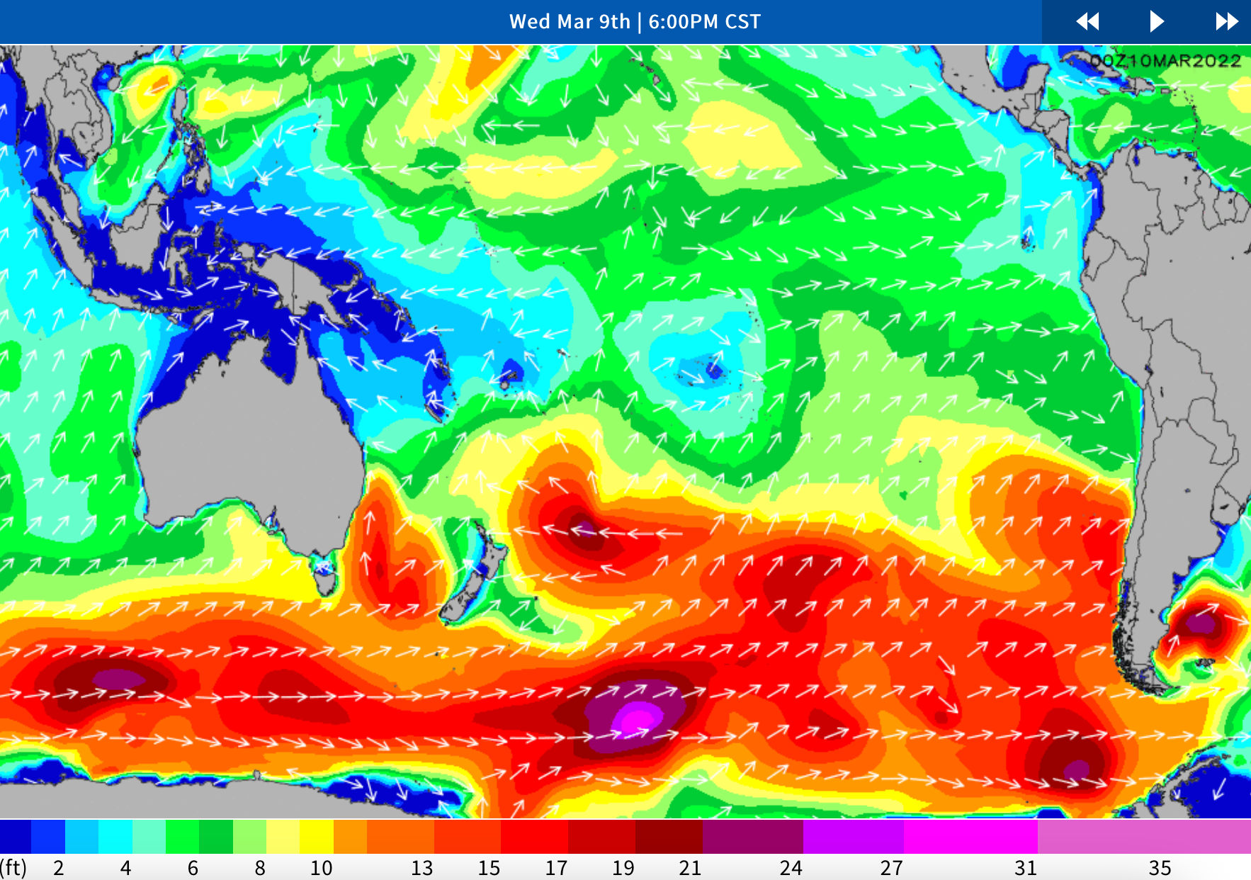
SPAC looks to send up more fun zone swell through mid month.
Further out, another fun zone SSW swell is scheduled to move in by next Tuesday, then peak through the middle of the upcoming week, setting up a new round of waist to shoulder high+ surf for many exposures on the 16th-17th. Similar strength shot of SSW swell potential for the following weekend, 19th-20th. We’ll keep you posted on the progress of these storm/swell systems as they develop.


Winds/weather:
Costa Rica: Steady NE winds for the northernmost spots, persist all day. The rest of North CR sees light+/moderate offshores for the first part of the mornings, shifting to mainly moderate SSW-SW-W winds later morning through the afternoon, then looking to ease later afternoon/evening.
Long Term Forecast Analysis (Monday, March 7th and Beyond)
SPAC Overview:
Overall a slightly slower version of the weekend Monday and early Tuesday. A small but playful mix of left over S-SSW swell should kick next week off as the weekend swell eases. Exposed breaks will continue to see knee to chest high surf, with lully set waves at better exposures and magnets.
We’ve got a couple new pulses expected to help bolster the surf again. A mix of longer-period S-SSW swell moves in Tuesday and Wednesday. This pulse could top out with around 3 feet of deepwater swell mid to late Wednesday the 9th holding size Thursday the 10th and lingering into Friday the 11th. Wave heights are expected to build into the waist to chest high+ range, with standouts/deepwater spots seeing sets going potentially head high-overhead during the peak.
Further out, the models are showing a small to moderate system east of New Zealand kicking up some better angled SSW that could start arriving next weekend (the 12th-13th). It does look like the storm activity in that area has been getting the downgrade over the past couple days, so although we’re seeing more activity, it’s hard to say if it will result in any notable swells much further out. Likely we’re going to see wave heights move back up a notch, with more waist to chest high+ surf by the end of next weekend, with potential for reinforcing energy to help maintain at least waist to chest high+ surf at SSW exposures through mid month. Stay tuned for updates.
The first full day is looking better and better: 4-5ft, 14mph ENE, 3.5ft 16s SSW (204º). (Cautionary Note: 204º is in our blockage window so may impede some of the flow, but some should bend in.)


We are now within the forecast window albeit the medium confidence level window. But overall, today's 17-day snapshot is more favorable than the snapshot from 17 days earlier. The forecast for our inital day is promising and the winds are back in the dominant offshore pattern again. If everything remains steady it looks like a comfy post-travel surf day with tides, swells and winds in cooperating spirits.


Costa Rica: Steady NE winds for the northernmost spots, persist all day. The rest of North CR sees light+/moderate offshores for the first part of the mornings, shifting to mainly moderate SSW-SW-W winds later morning through the afternoon, then looking to ease later afternoon/evening. Central and southern CR will mostly see a continued diurnal wind pattern with light/variable to very light offshore flow in the early mornings trending to light+/locally more onshores in the afternoons, looking strongest in southern regions.
Long Term Forecast Analysis (Thursday, March 3rd and Beyond)
SPAC Overview:
Modest scale SW swell shows a little more size by the half half of the week, putting more well exposed spots in waist-stomach high surf on Thursday. Friday is up a notch as a fresh SSW/S swell starts to join in. That new swell shifts more south and peaks for the weekend, for waist-chest-shoulder high waves on Saturday and into Sunday morning. Slow fade follows by the end of the weekend. Trend towards gradually easing size continues through early next week.
Further out, there is potential for a better, longer-period SSW/S swell during the 9th-11th, and again for the 13th-15th time frame. We’ll keep you posted on the progress of those storm/swell systems as they develop.
In solidarity to our friends in Ukraine we stand, hand in hand, and honor your colors!

Indeed, the next couple days are very small. Dismal is a more accurate characterization. But in the cycle of swells having a few off days in not usual--that is why we take trips for 10-16 days.
The first positive indicator I see is the stronger shifting to more southerly swells. There are still a number of dominant swells in the upper-teens but increasing emphasis in the lower-teens, single digits and 80/90s (SW, SSW, S, respectively). These are our desired swell windows.
Another good indicator are the longer swell periodicities... 14, 15, 16, 17 secs. Now, what really blows my mind is that I briefly popped into to see the forecast this morning and it was a foot or so larger (4-4 ft or 4-5 ft) during March and many of the periodicities dropped off a second or two. This is an interesting phenomena in this forecast service!
Winds/weather:
Costa Rica: Steady NE winds for the northernmost spots, persist all day. The rest of North CR sees light+/moderate offshores for the first part of the mornings, shifting to mainly moderate SSW-SW-W winds later morning through the afternoon, then looking to ease later afternoon/evening. Central and southern CR will mostly see a continued diurnal wind pattern with light/variable to very light offshore flow in the early mornings trending to light+/locally more onshores in the afternoons, looking strongest in southern regions.
Long Term Forecast Analysis (Monday, February 28th and Beyond)
SPAC Overview:
Next week starts off small as a SSW pulse fades to waist high or under at most spots from Monday afternoon through Tuesday. By mid week, a new round of modest scale SW swell moves in with waist-stomach+ high waves at good exposures on Wednesday/Thursday, 2nd-3rd. Bit more size due off another SSW swell which beings filling in on Friday, then peaks over the weekend, 5th-6th, for waist-chest high surf.
Further out, smaller pulses of SSW swell scheduled for most of the following week, then there is potential for a stronger, longer-period SSW swell during the 11th-13th time frame. We’ll keep you posted on those Southern Hemis as they develop and head our way.
The out days of the long-range forecast are an improvement. Is it a trend? Is it a passing blip? Time will tell. Bring plenty of books but be hopeful they won't be needed. Not much to say in the experts' written long-range forecast analysis.
There appears to be more 3-4 ft surf in the 2-week forecast in today's outlook. I am also looking for more SW to S swell. At least it is appearing to be moving to that place.
More cruising and comparing of the long-range forecasts looking for little morsels of hope in the larger and longer periodicities. We are still in the marginal zone but probably something in the Wash. Generally a more favorable forecast in the written summary below.

Sunday, January 30th: 2-4′ surf from SSW swell mix starts to ease, NW energy backs off as well.
Consistency and size are going to be begin backing off for the swell mix. SSW energy show a slower exit though, and wave heights are likely to continue running knee to chest high for standouts when the tide is working. Best combo breaks may continue to see a few unexpected peaks early on. High tide slows most spots midday-early afternoon. Breezy NE winds continue for areas typically affected by the Papagayo winds (North CR through Nicaragua).
Breezy NE winds will effect the area between the Nicoya Peninsula and El Salvador.
Winds/weather:
Costa Rica: Breezy NE wind event due Saturday and Sunday due to a cold frontal system moving through the US East Coast Friday/Saturday. Winds could be blowing 10-20 kt, easing Monday, but with lingering offshores especially for the northernmost spots. Central and southern CR will mostly see a continued diurnal wind pattern with light/variable to very light offshore flow in the early mornings trending to light+ onshores in the afternoons.
Long Term Forecast Analysis (Monday, January 31st and Beyond)
SPAC Overview:
SSW swell eases into next week, as a reinforcing pulse of SW energy starts to fill in late Sunday into Monday. This longer-period pulse looks like its going to favor spots with a little more westerly exposure due to the wide angle (210-220). For most exposed breaks we’re looking at thigh to waist high+ surf during the peak Tuesday-Wednesday. Standouts could see a few bigger stomach to chest high+ sets, although I wouldn’t expect much consistency with this one. Size lingers through the second half of the week, then a new, slightly larger SSW-SW swell is scheduled to roll in next weekend, 5th-6th.
The storm producing next weekend’s swell is currently south of French Polynesia generating measured seas at around 20-25 feet. It’s not super strong, but some of the fetch is at least pointed in the right direction, and could result in a 2+ feet of deepwater swell during the peak. That means surf potentially running waist to head high at standouts during the peak. It’s still a little too early to call with confidence, but we’ll have updates for you as the time approaches.
Further out, there is potential for another modest scale SSW swell arriving mid the following week (2/8-2/9). The 73 hour models are pretty optimistic on this one at the moment, with the storm producing wave heights in the 25-30 foot range with a somewhat-favorable fetch. Then the storm regroups for a better northward push of broader (albeit weaker) fetch SSW of the Pitcairn Islands about 156 hours out. So it could be a little 1-2 punch of energy, with the combined peak around the 1oth/11th of February. We’ll keep you posted on the progress of that storm/swell system as it develops.
NPAC Overview:
The NPAC storm track has shifted back to higher latitudes lately, with not much swell being aimed at Central America. At this point, only small scale background energy from the North Pacific is expected next week and beyond. We’ll let you know of any changes in that outlook.
Just meandering and looking for the transition from NW to SW swells and how the El Niño may be affecting things. The chart below shows some increased southerly influence but it is mostly of the small end.

Thursday, January 27th: 2-3′ waves off easing SSW swell, new NW swell shows at winter breaks.
Fading SSW swell and shorter-period S swell mix, for thigh-waist high surf at good exposures, as top breaks see some better sets early. New NW swell starts to move into best wintertime spots, with similar size waves. Mind the mid AM high tide, which bogs down the surf at most areas.
Friday, January 28th: 2-3′ surf from SSW swell mix, more NW swell for top exposures.
For most spots it’s a continue mix of modest scale SSW swell with thigh-waist high waves. Standout winter breaks see some better sets from a peaking NW swell. Best combo breaks pull in some peaks. Mid AM high tide slows most spots.
Winds
Costa Rica: Morning offshore winds out of the NE for North CR, with a light+ to periodically more sea breeze in the afternoons for most spots, strongest on Friday. Northernmost spots stay offshore all day. Central and southern CR will see a diurnal wind pattern with light/variable to very light offshore flow in the early mornings trending to light+ onshores in the afternoons. [Rod Note: This is def atypical for this time of year when the offshores should be dominant all day.]
Long Term Forecast Analysis (Saturday, January 29th and Beyond)
SPAC Overview:
Old SSW swell winds down going into the weekend, as a reinforcing SSW pulse moves in, for mainly thigh to waist high surf Saturday. Sunday holds, with the SSW pulse easing and some new, long-period SW swell slowly creeping up. The modest scale swell peaks/holds for the first part of next week, 31st-2nd, with waist-stomach high surf at many exposed spots and shoulder high+ waves at standouts. Those waves taper off by the second half of the upcoming week, then a new, similar size SW swell is scheduled to roll in by the following weekend, 5th-6th, with locally fun zone surf.
Further out, there is potential for another modest scale SSW swell in the 10th-12th time frame. So nothing much, but still some waves. We’ll keep you posted on the progress of those storm/swell systems as they develop.
NPAC Overview:
The North Pacific has had storms tracking through lower latitudes and reaching the swell window for best exposed areas of Central America. An older NW swells will be easing going into the weekend, while a bit steeper-angled/more selective NW swell joins in. That mix is good for waist high+ waves at the better winter breaks on Saturday, as standouts hit shoulder high. Surf tapers off on Sunday, then the trend towards smaller size continues into next week.
The NPAC storm track has shifted back to higher latitudes lately, with not much swell being aimed at Central America. At this point, only small scale NW pulses, mainly staying under waist high, are scheduled through the first third of next month. We’ll let you know of any changes in that outlook.


