


Central America Premium Analysis
The Bottom Line
- Swell Trend: Slow fading SSW swell through mid week
- Watch Out For: Early afternoon high tide slows the surf down at most spots
- Other Tidbits: Fresh SSW swell moves in this weekend
Tuesday, June 8th: Slow easing SW/SSW swell for 3-4′+ surf. Modest scale, mid-period SW/SSW swell mix shows most size in the morning, with waist to chest high+ waves at lots of exposed spots, and some better sets at top breaks. Surf size eases a bit during the afternoon as the swell blend tapers off. Early afternoon high tide will slow things down for most areas.
Wednesday, June 9th: 2-3’+ waves off fading SW/SSW swell. Mid-period SW/SSW swell combo continues to gradually ease, showing strongest in the morning for waist-stomach high surf at many exposures, as standouts pull in better sets. Wave size will slowly back slide as the day goes on and the swell blend eases. High tide in the early afternoon bogs the waves down for most spots.
Winds/weather: Diurnal wind pattern prevails.
Costa Rica: Light/variable to light offshore morning winds for most areas, while northernmost spots see more moderate AM offshore flow. Northern CR sees moderate+ southerly flow develop each afternoon, while central/southern regions see light and variable onshore flow.
Long Term Forecast Analysis (Thursday, June 10th and Beyond)
SPAC Overview:
A recent slow down in SPAC storm/swell production leads to smaller surf for the back half of this work week. Old SSW swell surf eases down to around waist-chest high for lots of spots on Thursday, then Friday’s waves fade down another notch.
Fresh run of steep angled, long-period SSW/S swell set up by a storm spinning off of South America will move in for the weekend. The southerly swell fills in through the day on Saturday, pushing in chest-shoulder-head high waves during the afternoon, then peaks on Sunday/Monday with head high+ surf and better sets at good exposures.
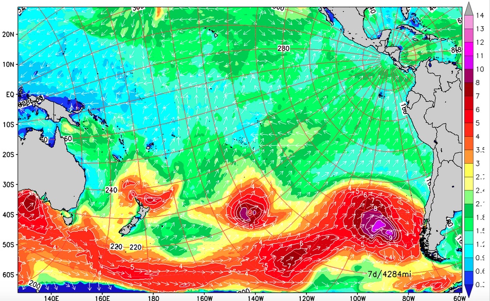
Fresh S swell on the way for the weekend.
Reinforcing SSW swell joins in to maintain those heights through mid next week, 15th-16th. Waves will be winding down going into the back half of the upcoming week. By next weekend, it looks like a stronger, longer-period round of SW swell will be building in. That swell is due to peak by the 21st-22nd, with potential for easily overhead surf at better breaks. We’ll keep you posted on the progress of these Southern Hemis as they develop.
Tropics:
There is a disturbance located about 700 miles south of Baja, but it’s
not expected to last long. Nothing new is due to develop over the next
few days.
No comments:
Post a Comment