- John's first ride at SR's Cove
- David's Bonzer 2 works better than initial version
- Rod's GryptaLite works as advertised -- I am now "wax free"


SURFLINE.COM Virtual Buoy Forecast
Model Cycle: 2021 APR 17 18Z
Time Zone: GMT - 6 hours
-------------------------------------------------------------
             SURF    SURF DIR  SWELL  PERIOD   WIND    WND/DIR
             (ft)       (deg)   (ft)   (sec)   (kts)     (deg)
            -------  --------  -----  ------  -------  -------
4/17  12pm   3 -  7   SW 215    4.1    14.9    3 -  4   NW 323
4/17   6pm   3 -  7   SW 213    4.3    14.6    7 - 10  WSW 239

4/18   6am   3 -  6   SW 214    4.0    14.2    0 -  0   SW 221
4/18  12pm   3 -  6   SW 212    3.8    14.1    8 - 11  SSW 201
4/18   6pm   3 -  6  SSW 208    3.7    14.0    7 - 10   SW 218

4/19   6am   3 -  6   SW 211    3.8    14.1    4 -  6    N 353
4/19  12pm   3 -  6   SW 212    3.8    13.8    7 - 10  NNW 332
4/19   6pm   4 -  9   SW 221    3.8    20.4    5 -  6  SSW 208

4/20   6am   4 -  9  SSW 208    4.0    19.1    7 -  9   SE 139
4/20  12pm   4 -  9  SSW 209    4.0    18.9    4 -  6    N   4
4/20   6pm   4 -  8  SSW 196    4.2    17.9    2 -  2   NW 320

4/21   6am   4 -  8  SSW 197    4.2    16.7    4 -  6   NW 327
4/21  12pm   4 -  8  SSW 198    4.2    16.1    5 -  7    W 272
4/21   6pm   3 -  7  SSW 199    4.3    15.5    3 -  4  SSW 199

4/22  12am   4 -  8  SSW 198    4.5    15.2    2 -  3  SSE 169
4/22   6am   5 - 10  SSW 200    4.8    19.1    6 -  9  ENE  56
4/22  12pm   5 - 11  SSW 197    5.1    18.5    6 -  8  SSE 156
4/22   6pm   5 - 10  SSW 198    5.1    17.7    6 -  8  SSE 152

4/23   6am   5 - 10  SSW 197    5.2    16.7   10 - 14  ENE  67
4/23  12pm   4 -  9  SSW 196    5.0    16.4    7 -  9    S 183
4/23   6pm   4 -  9  SSW 196    4.8    16.2    6 -  9    S 185

4/24   6am   4 -  8  SSW 198    4.4    15.3    5 -  7  ENE  77
4/24  12pm   3 -  7  SSW 197    4.3    15.1    5 -  7  SSW 199
Central America Premium Analysis
The Bottom Line
- Swell Trend: Fun SW/SSW swell holds going into the weekend, slowly easing Sun
- Watch Out For: High tides in the early AMs and evenings
- Other Tidbits: SPAC setting up stronger swell for next week
Saturday, April 17th: 4-6′+ surf from holding SW/SSW swell. Good run of SW/SSW swell keeps many exposed spots in shoulder high+ to a foot+ overhead zone waves, as standouts see some better sets. Mind the high tides early morning and again by the evening, as they tend to slow down/fatten up the surf at most breaks.
Sunday, April 18th: 4-6′ waves off slow easing SW/SSW swell. Gradually fading SW/SSW swell is still good for shoulder high to a foot+ overhead surf at exposures in the morning, then look for those waves to taper off some during the day. High tides, early morning and evening, will be slowing down the surf at most spots.
Winds/weather: Diurnal wind pattern for the weekend.
Costa Rica: All regions have light to locally more offshore mornings, followed by light+/moderate afternoon onshores.
Long Term Forecast Analysis (Monday, April 19th and Beyond)
SPAC Overview:
There’s been a steady stream of progressively stronger storms moving through the central SPAC and into the east end of the ocean recently. Those lows have set up the good run of Southern Hemi swell which we’re seeing now, and they are whipping up more waves for next week.
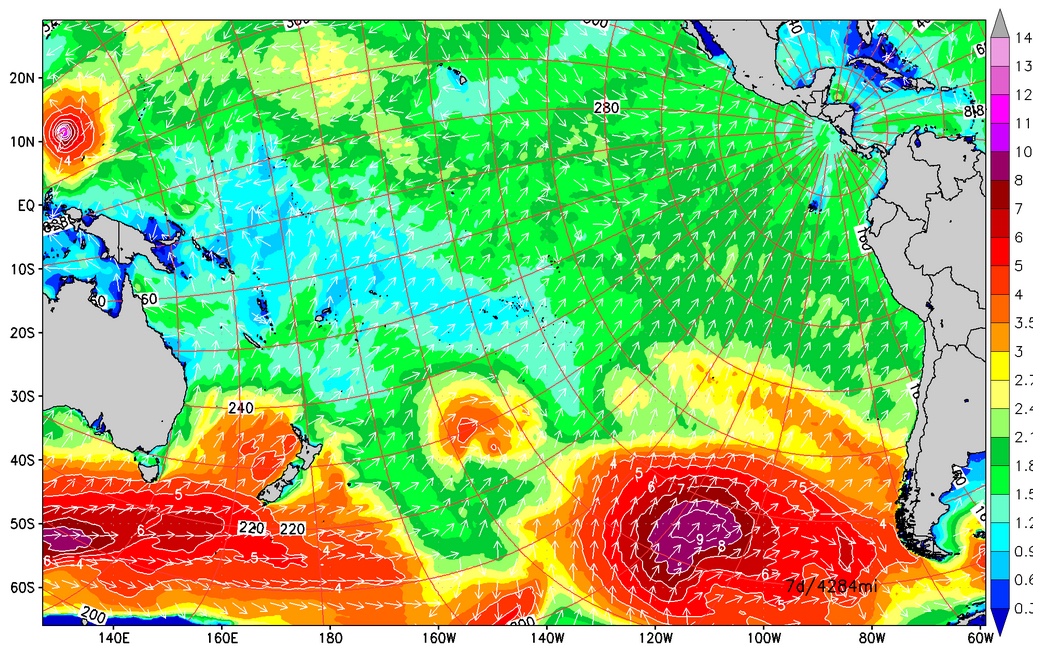
SPAC setting up stronger swell for next week.
Next Monday sees the first forerunners of a fresh SSW swell which was cranked out by a storm with satellite confirmed winds in the 50-60kt range and seas to 45’+. That swell fills in through Tuesday then peaks mid next week, 21st, with many spots seeing consistent head+ waves and better sets. More size follows for the back half of the upcoming week, thanks to an intense system spinning off the south end of South America with satellite measured seas hitting 50′. The resultant, extra long-period SSW swell will build in through Thursday, 22nd, then maxes out on Friday/Saturday, 23rd-24th, putting lots of spots in easily overhead surf, while focal points go double overhead+. Those waves wind down going into the last week of this month. We’ll keep you posted on the progress of that powerful Southern Hemi as it heads our way.
No comments:
Post a Comment