
SURFLINE.COM Virtual Buoy Forecast
Model Cycle: 2021 APR 15 12Z
Time Zone: GMT - 6 hours
-------------------------------------------------------------
             SURF    SURF DIR  SWELL  PERIOD   WIND    WND/DIR
             (ft)       (deg)   (ft)   (sec)   (kts)     (deg)
            -------  --------  -----  ------  -------  -------
4/15   6am   3 -  7   SW 219    4.0    16.6   10 - 14  ENE  50
4/15  12pm   4 -  8   SW 218    4.1    16.2    5 -  7  SSE 165
4/15   6pm   3 -  7   SW 218    4.2    15.8    7 -  9  SSE 161

4/16   6am   3 -  7   SW 218    3.9    15.8    5 -  8   SE 141
4/16  12pm   3 -  7   SW 217    3.8    15.7    2 -  3    S 184
4/16   6pm   3 -  7   SW 215    3.8    15.6    5 -  7  WSW 235

4/17   6am   3 -  7   SW 212    3.8    15.4    2 -  3    S 176
4/17  12pm   3 -  7   SW 214    4.0    14.9    3 -  4  SSW 199
4/17   6pm   3 -  7   SW 213    4.1    14.6    5 -  6  SSW 200

4/18   6am   3 -  6   SW 214    3.9    14.2    6 -  8   SE 141
4/18  12pm   3 -  6  SSW 208    3.7    14.0    2 -  3  SSE 164
4/18   6pm   2 -  5  SSW 205    3.5    13.9    5 -  7    S 176

4/19  12am   3 -  6  SSW 207    3.6    14.1    9 - 12  SSE 153
4/19   6am   2 -  5  SSW 208    3.4    14.1    3 -  4   SE 143
4/19  12pm   2 -  5  SSW 209    3.5    13.9    3 -  4  WNW 296
4/19   6pm   2 -  5   SW 211    3.6    13.6    1 -  2  WSW 256

4/20   6am   4 -  8  SSW 208    3.8    19.1    1 -  1  ENE  50
4/20  12pm   4 -  8  SSW 209    3.8    18.9    3 -  4   SW 217
4/20   6pm   4 -  8  SSW 198    3.9    17.9    4 -  6   SW 218

4/21   6am   4 -  8  SSW 198    4.1    16.6    4 -  6  NNE  20
4/21  12pm   4 -  8  SSW 198    4.2    16.1    4 -  6    N   5
4/21   6pm   4 -  8  SSW 199    4.4    15.5    6 -  8    E  96

4/22   6am   5 - 10  SSW 202    4.8    19.1    8 - 11  ENE  61
The Bottom Line
- Swell Trend: Fun SW/SSW swell peaks/holds back half of the week
- Watch Out For: Large tide swings, with deep highs for the early AMs and later afternoons
- Other Tidbits: SPAC setting up stronger swell for next week
Thursday, April 15th: 4-6′+ surf from peaking SW/SSW swell. Good run of SW/SSW swell puts many exposed spots in shoulder high+ to a foot+ overhead zone waves, as standouts see some better sets. Mind the deep high tides early morning and again by later afternoon, as they tend to slow down/fatten up the surf at most breaks.
Friday, April 16th: 4-6′+ waves off holding SW/SSW swell. Steady SW/SSW swell maintains head high+ surf and better sets at good exposures, while focal points see some more size on sets. Deep high tides, early morning and again late afternoon, will be slowing down the waves at most spots.
Winds/weather: Typical wind pattern prevails.
Costa Rica: Northernmost areas have persistent offshore flow most of the day, with spots from Playa Negra southward seeing onshores by the afternoons. Central and southern regions have light offshore mornings, followed by light+/locally more afternoon onshores.
Long Term Forecast Analysis (Saturday, April 17th and Beyond)
SPAC Overview:
There’s been a steady stream of progressively stronger looking storms moving through the central SPAC and into the east end of the ocean recently. Those lows have set up a good run of Southern Hemi swell for this week and beyond. SW/SSW swell holds going into the weekend, keeping good spots in head-high to 1-2′ overhead waves. Those heights slowly taper off by the end of the weekend, but there will still be plenty of head surf left at good spots through Sunday.
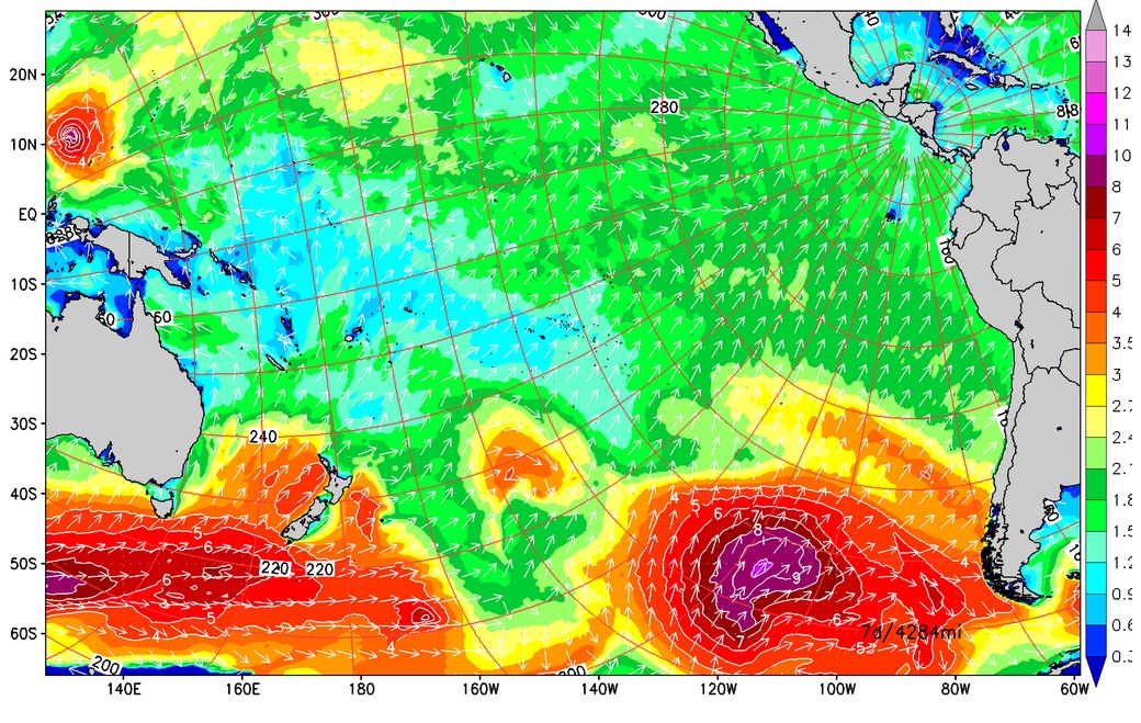
SPAC setting up stronger swell for next week.
Next Monday sees the first forerunners of a fresh SSW swell move in. That swell fills in through Tuesday then peaks mid next week, 21st, with many spots seeing consistent head+ waves and better sets. Larger surf follows for the back half of the upcoming week. An intensifying storm is currently spinning in the central SPAC and tracking towards South America. That system will be pushing up a stronger Southern Hemi swell that will rise through Thursday, 22nd, then maxes out on Friday/early Saturday, 23rd-24th, putting lots of spots in easily overhead surf, while focal points see more size. We’ll keep you posted on the progress of that powerful Southern Hemi as it heads our way.
No comments:
Post a Comment